On that day, we performed the most normal functions, mapping marine habitat, when suddenly on the left side of the sight, we noticed an object, unknown, which was glittering, actually changing color, in fact it was a yellow, greenish, occasionally… and it was doing these circles in the sea-grass because the grain did not grow well this year.
This, according to our past experience, is a scenario that would make a good deal of media love (because the media does not write for themselves), and the public would love to read about an “alien-like” regular circles in the sea we found last year at the islands of Unija and Srakane and later found that they can also be found in Molat, Premuda and Dugi otok.
Even us, with our open mind, could not exclude the possibility that we have become an art colony for alien cubist tendencies. Of course, it is not excluded that this was, as some of the UFOlogists suggest, a landing site for spaceships. However, the credibility of this theory is a bit undermined by the fact that an airplane like Boeing 747 can land in 2 kilometers area. It is hard to imagine that aliens need half of the Adriatic Sea to land. Besides, we all know that aliens are teleporting…
Now that we’ve excluded these “most likely” theories and when the news of circles has literally spotted the globe, it is time for Sunce to write something on its page as we noticed a huge increase in visits to our web site, and we did not remember to provide first-hand information . Now that the media noise has calm down, perhaps we can analyze possible theories of circuitry in the sea-bed a little bit more.
The fact is that we can only speculate when they formed, from what and why did they form. In fact, we would prefer to use a word formed rather then created, but we can not claim either with 100% security (formed implies natural processes while created implies human activity).
To begin with, we would like to bring up facts. The Sunce Association maped marine habitats for future Natura 2000 area for Public institution “Nature” in summer 2013 (near islands of Unija, Susak and Srakane).
Habitat mapping was being carried out to effectively manage the protected areas and areas of the future Natura 2000 network, and Sunce was one of the leading organizations in the Republic of Croatia in this regard.
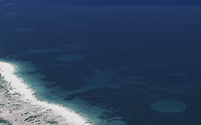
In the preparation of the research, we reviewed the database of digital orthophoto (airborne) images based on Arkod, which was set up by the Agency for Payments in Agriculture, Fisheries and Rural Development. In these photos we saw this:
Arial photo of Unije island southeastern coast
Certainly it did not appear to be a natural occurrence with regard to the sample. Ten bright circles (pure sediment, sand) imprinted in the meadow of Posidonia oceanica on the southeastern coast of Unija island, each circle 50 meters in diameter and about 300 meters away from each other and 100 meters away from the coast. Along the northeast coast of Great and Small Srakan, similar thing. Ten clean circles, approximately 50 meters in diameter, and three circles that are not quite clean-cut. It seems that the posidonias have partially grown over. On Srakanam, the distance between the circles varies more than on Unija, but the pattern again clearly exists.
Photo of a partially growen-over circle
Since it was possible, for some reason, that this was work on post-processing aerial photos and that the circles in reality did not exist, we checked the footage on Google Maps and found that they were there. To be sure when we arrived on the field we dived to the location of one of the circles in front of the Srakan coast and learned that it was really there. At a depth of 20 meters, a dense meadow is Posidonia on the one hand, and a bright sediment in the interior of the circle, without one blob of Posidonia. The edge of the meadows is clearly cut off, just as if someone with a giant cannula removed the Posidonium. That does not mean that all the circles are such. That means that this is certainly the kind of circle we dived to.
Unfortunately, we did not even think about photographing or recording underwater in and around the circle. We will correct that next time. We simply could not imagine that circles would had gained so much publicity, and we were not there for circles or dealing with mysteries.
However, although we do not deal with mysteries, we deal with Posidonium. It is a law-protected and endangered Mediterranean endemic whose underwater meadows are one of the most important marine habitats of the Mediterranean. They are a hatchery, a nursery and a feeding place of a whole range of species, including many commercial types of fisheries.
Blacksmith in a meadow of posidonia
What is most interesting for readers is that Posidonium is the best possible defense against an invasive algal species of Caulerpa (which is still known by the fighting name of “killer algae”) because its meadows blocks its spread.
In other words, these interesting circles represent great and very likely irreversible damage, as Posidonium grows slowly, only 2 to 3 cm a year and is difficult to regenerate!
So, after returning to Split, we divided post photos on our Facebook Page in the hope that someone would come up with the solution to this “mystery”. However, all we got was that the same circles, 50 meters large and fairly well spaced, were present on Molat, Premuda and Dugi otok islands. On Dugi otok island, 28 of them (so much we have counted on the recordings which does not mean there weren’t any more).
As far as the last thing is concerned, it is easy to verify the age of aerial and satellite images. Records on Google Maps that show circles date back to July 2011, and for Arkod’s recordings we know that they were also made sometime in 2011. This means that the circles are certainly out there since July 2011 at least. When the State Geodetic Administration announces aerial photographs made before 1968, we may be able to find out if circles existed then.
Far from these assumptions and although many claim to know what is being done, until evidence is presented, no one can safely know how and when the circles have been formed. Here are some possible explanations in the order that is most likely to be ours.
1. Explosions
Underwater explosions have proven to create proper circles in the underwater world. Tracks of dynamite hunting are unfortunately often present in the Adriatic, and in some parts, dynamite can also be considered as a traditional fishing tool (here is an example that tradition is not always worth preserving). Users, still known as “noblemen”, can often be recognized by their fingers, and in addition to the enormous damage they inflict on the underwater, there are known cases nearby divers deaths.
However, our circles differ from the circles generated in the dynamite in their repetition and size. The footage below shows the consequences of dynamite hunting. Circles are of different sizes (these in the photo vary from 5 to 15 meters) and are incorrectly arranged.
Of course, the illegal dynamite hunting can leave more regular patterns such as those in the next image (Kornat Island), but there are still clearly visible variations in circle sizes (10 to 30 meters).
We are not experts, but it would be logical to conclude that randomly casting dynamites, probably home-made or representing various military legacies (such as manual bomber or thunderbolt), can only cause each holes in posidonium to be equally large. In other words, we assume that something like this is necessary first, and then certain knowledge of explosives. Unless it is a case of a culprit who is a former specialists and suffers from an obsessive compulsive disorder, all his towels are arranged “on the line” and the dynamite holes are mathematically precise.
7. Other